


404
+1-313-307-4176
Terrestrial Laser Scanning Market Report

Terrestrial Laser Scanning Market Size, Share, Trend, Forecast, Competitive Analysis, and Growth Opportunity: 2024-2032
Terrestrial Laser Scanning Market is segmented by Solution(Terrestrial Laser Scanning System [Hardware and Software] and Terrestrial Laser Scanning Services [Oil & Gas, Mining, Infrastructure, Forestry & Agriculture, Transportation & Logistics and Others]), by Application (Building Information Modelling (BIM) [Architecture and Civil Engineering], Surveying [Monitoring Survey, Mining Survey, Topographical Survey, Forestry & Agricultural Survey, Monitoring Survey and Archaeological Survey], Research & Engineering, and Others [forensics & crash scene investigation, seismology exploration & detection], by Type(Phase-shift Scanner, Pulse-based Scanner and Mobile Scanner), and by Region (North America [The USA, Canada, and Mexico], Europe [Germany, France, The UK, Russia, and Rest of Europe], Asia-Pacific [China, Japan, India, and Rest of Asia-Pacific], and Rest of the World [Brazil, Saudi Arabia, and Others]).
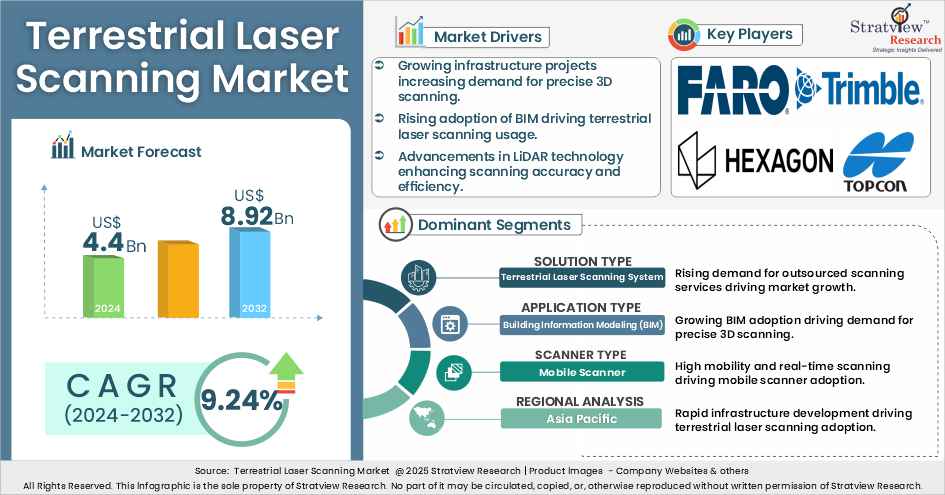
“Terrestrial laser scanning market value was US$4.4 billion in 2024 and is likely to grow at a robust CAGR of 9.24% in the long run to reach US$8.92 billion in 2032”.
Want to get a free sample? Register Here
Introduction
The terrestrial laser scanning market is a vital part of modern geospatial and surveying technologies, enabling high-precision 3D data acquisition for a wide range of applications. It encompasses advanced solutions such as phase-shift, pulse-based, and mobile scanners, along with comprehensive services for modeling and mapping. The market is expected to grow steadily due to increasing investments in infrastructure development, digital asset management, and real-time spatial analysis. Segmented by solution, application, type, and region, the market presents significant opportunities for innovation in land surveying, building information modelling (BIM), and research engineering. The rising need for accurate geospatial data, efficient construction workflows, and enhanced decision-making capabilities is anticipated to drive the advancement of terrestrial laser scanning technologies globally.
Drivers
Recent Market JVs and Acquisitions:
In the terrestrial laser scanning market, companies are forming strategic partnerships and making acquisitions to strengthen their capabilities in 3D scanning, virtual modeling, and digital infrastructure applications. These collaborations aim to enhance software integration, expand service portfolios, and accelerate digital transformation across industries such as construction, oil & gas, and utilities.
Recent notable mergers and acquisitions (M&As) and joint ventures (JVs) include:
Recent Product Development:
The terrestrial laser scanning market is witnessing continuous innovation in scanning software and equipment, aimed at improving the accuracy, usability, and scope of 3D data analysis across complex environments. Companies are focusing on developing enhanced solutions for asset inspection, damage diagnostics, and structural analysis in industries like oil & gas and infrastructure.
Key product developments include:
|
Segmentations |
List of Sub-Segments |
Segments with High Growth Opportunity |
|
Solution - Type Analysis |
Terrestrial Laser Scanning System (Hardware: [Laser Scanners, Interface Devices, Wireless LAN Antenna, Inertial Measurement Systems, GPS/Positioning Systems, Digital Cameras, Others], Software), Terrestrial Laser Scanning Services (Oil & Gas, Mining, Infrastructure, Forestry & Agriculture, Transportation & Logistics, Others) |
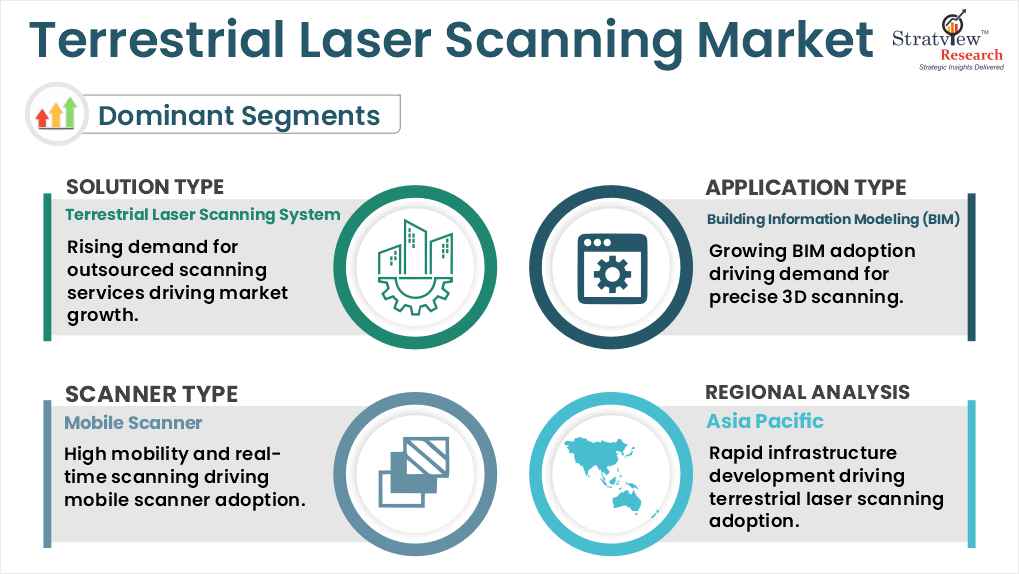
The terrestrial laser scanning services segment is projected to grow at the highest CAGR, driven by rising investments in advanced 3D scanning technologies by land surveyors worldwide. |
|
Application - Type Analysis |
Building Information Modeling (BIM), (Architecture, Civil Engineering), Surveying (Topographical Survey, City Modeling Survey, Mining Survey, Forestry & Agricultural Survey, Monitoring Survey, and Archaeological Survey), Research & Engineering, and Others (forensics & crash scene investigation, seismology exploration & detection) |
The Building Information Modeling (BIM) segment is expected to grow at the highest CAGR due to its widespread use in deformation analysis, asset management, and infrastructure upgradation. Governments in developed countries are prioritizing digital infrastructure through BIM adoption. |
|
Scanner Type Analysis |
Phase-shift Scanner, Pulse-based Scanner, and Mobile Scanner |
The mobile scanner segment is expected to experience strong growth owing to its ability to capture high-precision data in real time across dynamic environments, making it ideal for on-the-move land surveys. |
|
Regional Analysis |
North America, Europe, Asia-Pacific, and the Rest of the World |
The Asia Pacific region is projected to register the highest CAGR during the forecast period, supported by the growing use of terrestrial laser scanning technologies in land survey operations by leading firms in the region |
By Solution
"The terrestrial laser scanning services segment is expected to experience the highest growth in the market during the forecast period."
The terrestrial laser scanning market is segmented into systems (hardware and software) and services. Among these, the services segment is projected to grow at the highest CAGR due to increasing adoption of advanced 3D scanning technologies by land surveyors across various industries such as oil & gas, infrastructure, and agriculture. These services support efficient data modeling of immobile structures and high-value assets. The trend is especially prominent in developed economies where investment in modern land surveying and digital infrastructure is rapidly growing.
By Application
"The Building Information Modeling (BIM) segment is expected to grow at the highest CAGR during the forecast period."
The market is categorized into Building Information Modeling (BIM), surveying, research & engineering, and others. BIM is emerging as the fastest-growing application due to its increasing use in infrastructure upgradation, deformation analysis, and asset management projects. With governments in regions like North America and Western Europe prioritizing smart and digital infrastructure initiatives, BIM adoption is accelerating, driving demand for precise 3D scanning solutions.
By Scanner Type
"The mobile scanner segment is expected to witness the highest growth in the terrestrial laser scanning market during the forecast period."
The market is categorized into phase-shift, pulse-based, and mobile scanners. Mobile scanners are anticipated to grow the fastest due to their flexibility and ability to perform high-resolution scans in real-time across dynamic or large-scale survey environments. These scanners are particularly useful in urban planning, road and rail infrastructure mapping, and mining operations, where portability and speed are crucial. Their integration with GNSS and inertial navigation systems further enhances data accuracy and operational efficiency.
Want to get more details about the segmentations? Register Here
Regional Analysis
"The Asia-Pacific region is expected to experience the highest growth during the forecast period."
Regionally, the market is divided into North America, Europe, Asia Pacific, and the Rest of the World. Asia Pacific is expected to lead in terms of growth due to increasing investments in infrastructure development and land surveying technology. Countries such as China, India, and Japan are embracing 3D scanning techniques for urban development, mining, and agriculture. Prominent surveying firms in the region are adopting terrestrial laser scanning to improve accuracy and reduce project timelines, further fueling market expansion.
The terrestrial laser scanning market is highly competitive, with leading players focusing on precision mapping, advanced 3D modeling capabilities, and strategic partnerships to meet the evolving needs of industries such as construction, infrastructure, mining, and agriculture. These companies are at the forefront of developing integrated scanning systems that combine high-speed data capture, real-time processing, and enhanced spatial accuracy. Innovations in mobile scanning units, cloud-based data platforms, and AI-driven analytics are key differentiators. With global operations and strong R&D investments, these players ensure robust solutions for land surveying, smart city planning, and digital twin implementation.
Here is the list of the Top Players (Based on Dominance)
Note: The above list does not necessarily include all the top players in the market.
Are you the leading player in this market? We would love to include your name. Please write to us at [email protected]
This report provides market intelligence most comprehensively. The report structure has been kept so that it offers maximum business value. It provides critical insights into market dynamics and will enable strategic decision-making for existing market players as well as those willing to enter the market. The following are the key features of the report:
The global terrestrial laser scanning market is segmented into the following categories.
Terrestrial Laser Scanning Market, by Solution
Terrestrial Laser Scanning Market, by Application
Terrestrial Laser Scanning Market, by Type
Terrestrial Laser Scanning Market, by Region
With this detailed report, Stratview Research offers one of the following free customization options to our respected clients:
Company Profiling
Competitive Benchmarking
Custom Research: Stratview Research offers custom research services across various industries. In case of any custom research requirement related to market assessment, competitive benchmarking, sourcing and procurement, target screening, and others, please send your inquiry to [email protected]
The report is delivered digitally through our online portal. Buyers receive login credentials from our team to access the report and may update their credentials at any time after the initial login.
Delivery timelines depend on the status of the report:
For the most accurate delivery timeline, please contact us to confirm the current status of the report.
Yes. You may request a complimentary preview of the report through a video conference with our team.
Yes. The scope of the report can be fully customized to align with your specific research objectives and information requirements.
Please contact us at [email protected], and our team will be happy to discuss your requirements and propose a tailored solution.
Yes. Selected sections of the report can be purchased separately based on your requirements. Please contact us at [email protected] to discuss your needs.
Yes, AI can help gather publicly available information, but its outputs are only as reliable as the data it accesses. Stratview Research reports are built using validated data, extensive primary interviews with industry stakeholders, and the expertise of our experienced research team.
Additionally, many critical insights, including market dynamics, competitive intelligence, and industry-specific trends, are not publicly available and therefore cannot be captured through AI alone.
Terrestrial laser scanning is a method of capturing high-resolution 3D data of objects and environments from ground-based systems using laser technology. It is widely used in surveying, construction, mining, and heritage documentation.
The forecasted value of the terrestrial laser scanning market is projected to grow from US$4.4 billion in 2024 to US$8.92 billion in 2032, with a robust compound annual growth rate (CAGR) of 9.24%.
The market is segmented into three main types: phase-shift scanners, pulse-based scanners, and mobile scanners. Each type is suited for specific scanning needs based on range, speed, and accuracy.
Major growth drivers include the increasing adoption of TLS in BIM applications, advancements in GNSS networking for land surveying, and the rising use of software-as-a-service (SaaS) platforms for managing 3D scan data.
The Asia Pacific region is expected to grow at the highest CAGR, driven by growing infrastructure development, adoption of digital surveying technologies, and increasing investments in construction and transportation projects.
Key Challenges: • High costs: The initial investment in TLS systems, especially advanced laser scanners, can be expensive for smaller companies. • Data management: Processing and managing large datasets from high-resolution scans requires advanced software and significant computational resources. • Technical complexity: TLS systems require skilled operators and training, limiting their widespread adoption in regions with less technical expertise. • Conventional mapping techniques as a low-cost substitute for LiDAR: Traditional mapping methods like photogrammetry and manual surveying are still seen as cost-effective alternatives, which can hinder the widespread adoption of LiDAR-based TLS in certain industries.
The Terrestrial Laser Scanning market is evolving with advancements in technology and industry demands. Key Trends: • Integration with AI and machine learning: AI-powered analytics is being integrated into TLS systems to enhance data processing and automate tasks such as object recognition and feature extraction. • Use in autonomous vehicles: TLS technologies are increasingly being employed in autonomous trucks and vehicles for accurate environmental mapping and navigation. • Cloud-based data management: The adoption of cloud platforms to store and share TLS data in real-time is making the technology more efficient and accessible, especially for remote or large-scale projects.
Key companies include Trimble, FARO Technologies, Hexagon, RIEGL Laser Measurement Systems, Teledyne Technologies, and Topcon, among others.


WE ACCEPT


